


The North American Monsoon Season Explained
| Courtesy of the National Weather Service |
| Until the late 1970s, there was serious debate about whether a monsoon truly existed in North America. However, considerable research, which culminated in the Southwest Arizona Monsoon Project (SWAMP) in 1990 and 1993, established the fact that a bonafide monsoon, characterized by large-scale wind and rainfall shifts in the summer, develops over much of Mexico and the intermountain region of the U.S. Published papers at the time called this pattern by different names, including the "Summer Thunderstorm Season," "The Mexican Monsoon," "The Southwest Monsoon," and the "Arizona Monsoon." |
| In 2004, a major multinational research project was conducted in northwest Mexico and the southwest U.S. The North American Monsoon Experiment (NAME) sought to better describe the monsoon in North America, and increase our ability to predict it on a daily, weekly and seasonal basis. NAME showed that despite its many names, the weather pattern we see during the summer is not only a true monsoon, but it also affects the weather over a large portion of North America. Thus the generally accepted name is now "North American Monsoon." |
| The North American Monsoon is not as strong or persistent as its Indian counterpart, mainly because the Mexican Pleateau is not as high or as large as the Tibetan Plateau in Asia. However, the North American Monsoon shares most of the basic characteristics of its Indian counterpart. There is a shift in wind patterns in summer which occurs as Mexico and the southwest U.S. warm under intense solar heating. As this happens, the flow reverses from dry land areas to moist ocean areas. In the North American Monsoon, the low level moisture is transported primarily from the Gulf of California and eastern Pacific. The Gulf of California, a narrow body of water surrounded by mountains, is particularly important for low-level moisture transport into Arizona and Sonora. Upper level moisture is also transported into the region, mainly from the Gulf of Mexico by easterly winds aloft. Once the forests of the Sierra Madre Occidental green up from the initial monsoon rains, evaporation and plant transpiration can add additional moisture to the atmosphere which will then flow into Arizona. Finally, if the southern Plains of the U.S. are unusually wet and green during the early summer months, that area can also serve as a moisture source. This combination causes a distinct rainy season over large portions of western North America, which develops rather quickly and sometimes dramatically. Graphic 1 shows the general moisture sources for the North American Monsoon. |
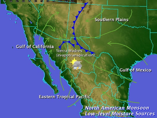 |
| Graphic 1: Moisture sources for the North American Monsoon. |
| Rainfall during the monsoon is not continuous. It varies considerably, depending on a variety of factors. There are usually distinct "burst" periods of heavy rain during the monsoon, and "break" periods with little or no rain. Monsoon precipitation, however, accounts for a substantial portion of annual precipitation in northwest Mexico and the Southwest U.S. Most of these areas receive over half their annual precipitation from the monsoon. |
| The North American Monsoon circulation pattern typically develops in late May or early June over southwest Mexico. By mid to late summer, thunderstorms increase over the "core" region of the southwest U.S. and northwest Mexico, including the U.S. and Mexican states of Arizona, New Mexico, Sonora, Chihuahua, Sinaloa and Durango. The monsoon typically arrives in mid to late June over northwest Mexico, and early July over the southwest U.S. Once the monsoon is underway, mountain ranges, including the Sierra Madre Occidental and the Mogollon Rim provide a focusing mechanism for the daily development of thunderstorms. Thus much of the monsoon rainfall occurs in mountainous terrain. For example, monsoon rainfall in the Sierra Madre Occidental typically ranges from 10 to 15 inches. Since the southwest U.S. is at the northern fringe of the monsoon, precipitation is less and tends to be more variable. Areas further west of the core monsoon region, namely California and Baja California, typically receive only spotty monsoon-related rainfall. In those areas, the intense solar heating isn't strong enough to overcome a continual supply of cold water from the North Pacific Ocean moving down the west coast of North America. Winds do turn toward the land in these areas, but the cool moist air actually stabilizes the atmosphere. |
| In addition to the lower level monsoon circulation, an upper level monsoon (or subtropical) ridge develops over the southern High Plains and northern Mexico. In June, this ridge is too far south over Mexico and actually blocks deep moisture from moving north into Arizona (Graphic 2). |
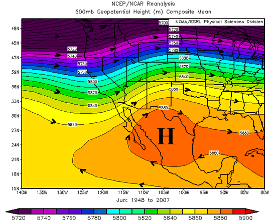 |
| Graphic 2: Mean 500mb height pattern, June. Subtropical high is strengthening over northern Mexico |
| However by late June or early July, this ridge shifts north into the southern Plains or southern Rockies (Graphic 3). As this shift takes place, mid and upper level moisture streams into Arizona, and low level moisture surges from Mexico meet less resistance. |
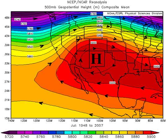 |
| Graphic 3: Mean 500mb height pattern, July. Subtropical high is near maximum seasonal strength over New Mexico. |
| This monsoon ridge is almost as strong as the one which develops over Asia during the summer. However, since the lower level moisture flow is not as persistent as in the Indian monsoon, the upper level steering pattern and disturbances around the ridge are critical for influencing where thunderstorms develop on any given day. The exact strength and position of the subtropical ridge also governs how far north the tropical easterly winds aloft can spread. If the ridge is too close to a particular area, the sinking air at its center suppresses thunderstorms and can result in a significant monsoon "break." If the ridge is too far away or too weak, the east winds around the high are inadequate to bring tropical moisture into the mountains of Mexico and southwest U.S. However, if the ridge sets up in a few key locations, widespread and potentially severe thunderstorms can develop. |
| It is important to note that the monsoon is not an individual thunderstorm. While the word "monsoon" accurately conjures up images of torrential rains and flooding, calling a single thunderstorm a "monsoon" is incorrect. A monsoon is a large scale weather pattern which causes our summer thunderstorms. |
| 500 mb graphics were produced using NCEP Reanalysis Derived data provided by the NOAA/OAR/ESRL PSD, Boulder, Colorado, USA. [Available on line at: Web site at http://www.cdc.noaa.gov ]. |
|
For further reading: Adams, D.K., and A.C. Comrie, 1997: The North American Monsoon. Bull. Amer. Meteor. Soc., 78, 2197-2213. Douglas, M.W., R.A. Maddox, K Howard, and S. Reyes, 1993: The Mexican monsoon. J. Climate, 6, 1665-1667. ____, 2004: The North American Monsoon. Reports to the Nation on our Changing Planet. NOAA/National Weather Service. [Available on line at: http://www.cpc.noaa.gov/products/outreach/Report-to-the-Nation-Monsoon_aug04.pdf ] Tang, M., and E.R. Reiter, 1984: Plateau monsoons of the Northern Hemisphere: a comparison between North America and Tibet. Mon Wea Rev., 112, 617-637. |